
A Detailed Uganda National Parks Map
An Overview of the Uganda National Parks Map | Major National Parks & Tourism Highlights
Uganda’s ten national parks sit spread across a country roughly the size of the UK, but they’re not evenly distributed: most cluster in the west and southwest, a couple sit remote and alone in the north and east and the distances between them vary from a comfortable half-day drive to a genuine 12 hour expedition. The map below shows where each park actually sits relative to Kampala, Entebbe, and each other, which matters more than it sounds: two parks that look close together on a small-scale map of Africa can still be a full day’s drive apart on the ground. Below the map, we’ve broken down each park individually: what’s actually there, how far it really is and when to go since a location pin alone doesn’t tell you much on its own.
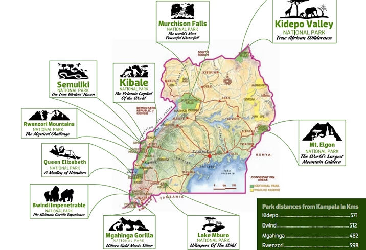
Uganda’s National Parks at a Glance
| Park | Region | Distance from Kampala | Known For |
|---|---|---|---|
| Bwindi Impenetrable | South West | about 9–10 hrs by road (or 1–1.5 hr flight) | Mountain gorilla trekking |
| Mgahinga Gorilla | South West | about 9–10 hrs by road (or flight to Kisoro) | Gorillas, golden monkeys, volcano hiking |
| Queen Elizabeth | West | 6–8 hrs by road | Tree-climbing lions, Kazinga Channel |
| Kibale Forest | West | 6 hrs by road (or flight via Kasese) | Chimpanzee tracking |
| Murchison Falls | North West | 5 hrs by road (or flight to Pakuba) | The Nile, the falls themselves, big game |
| Kidepo Valley | Far North West | 10–12 hrs by road (or about 2 hr flight) | Remote wilderness, cheetahs, ostriches |
| Lake Mburo | South West, enroute | 3–4 hrs by road | Zebras, walking safaris, boat cruises |
| Semuliki | West, near DRC border | Near Fort Portal | East Africa’s only lowland rainforest |
| Rwenzori Mountains | West | Gateway at Kasese | Multi-day mountain trekking |
| Mount Elgon | East | 4–5 hrs by road | Sipi Falls, caves, extinct volcano hiking |
Bwindi Impenetrable National Park
Where it is: Southwestern Uganda, on the edge of the Albertine Rift, bordering the Democratic Republic of Congo.
What to do: Mountain gorilla trekking across four sectors (Buhoma, Ruhija, Rushaga, Nkuringo) at $800 per person, the longer Gorilla Habituation Experience in Rushaga at $1800 per person, guided forest walks and Batwa cultural visits.
How to get there: By road from Entebbe or Kampala roughly 9–10 hours. By air, a scheduled flight to Kihihi airstrip (serving Buhoma and Ruhija) or Kisoro airstrip (serving Rushaga and Nkuringo) cuts this to under two hours. If you’re arriving via Rwanda, Kigali sits only 4–5 hours from Bwindi by road via the Katuna or Cyanika border crossings.
Best time to visit: Uganda’s two dry seasons, December–February and June–August, offer the easiest trekking conditions, though gorilla trekking runs year-round.
Mgahinga Gorilla National Park
Where it is: Uganda’s smallest national park, in the far southwest, part of the Virunga volcanic range shared with Rwanda and DR Congo.
What to do: Gorilla trekking (a single habituated family, shared across the border region), golden monkey tracking and hiking any of the park’s three volcanoes: Muhabura, Gahinga and Sabyinyo.
How to get there: Reached via Kisoro, roughly the same distance and routing as Bwindi’s southern sectors.
Best time to visit: Same dry-season logic as Bwindi.
Queen Elizabeth National Park
Where it is: Southwestern Uganda, near Kasese, straddling the equator.
What to do: Game drives in search of the tree-climbing lions of the Ishasha sector, a boat cruise on the Kazinga Channel (one of the highest hippo concentrations in Africa), chimpanzee tracking in Kyambura Gorge and crater lake drives in the Kasenyi area.
How to get there: By road from Kampala, 6–8 hours via either the Mbarara route (through Lake Mburo) or the Fort Portal route (through Kibale). Both roads are tarmac for most of the way. Combines naturally with Kibale, Bwindi and Lake Mburo on the same circuit.
Best time to visit: Dry season for easier game viewing, though the Kazinga Channel boat cruise runs well year-round.
Kibale Forest National Park
Where it is: Western Uganda, south of Fort Portal.
What to do: Chimpanzee tracking at $300 per person (Uganda’s highest sighting odds, above 90%), the longer chimpanzee habituation experience at $400 per person, guided walks through Bigodi Wetland Sanctuary and birdwatching across the park’s 13 primate species and 370+ recorded bird species.
How to get there: By road from Kampala or Entebbe, roughly 6 hours. By air, a flight to Kasese followed by about an hour’s drive.
Best time to visit: Year-round, though the dry season offers easier underfoot conditions on the tracking trails.
Murchison Falls National Park
Where it is: Northwestern Uganda, Uganda’s largest national park, where the Nile forces itself through a narrow gorge before the falls themselves.
What to do: Game drives across savannah holding elephants, lions, giraffes, and buffalo, a boat cruise to the base of the falls, a hike to the top of the falls for the view down into the gorge and chimpanzee tracking in Budongo Forest at the park’s southern edge.
How to get there: By road from Kampala, roughly 5 hours via Masindi. By air, a scheduled flight direct to Pakuba airstrip within the park.
Best time to visit: Dry season (December–February, June–September) for the easiest game viewing; the falls themselves are dramatic year-round.
Kidepo Valley National Park
Where it is: Uganda’s most remote park, tucked into the far northeastern corner near the borders with South Sudan and Kenya.
What to do: Game drives across the Narus Valley (the park’s dry-season wildlife hub), spotting species found nowhere else in Uganda cheetahs, ostriches and bat-eared foxes among them plus cultural visits with the Karamojong community.
How to get there: By road from Kampala, 10–12 hours via Gulu and Kitgum, requiring a 4×4. By air, a scheduled flight of roughly 2 hours direct to Kidepo airstrip, the realistic option for most travelers given the road distance.
Best time to visit: Dry season (September–March) concentrates wildlife around the Narus Valley’s permanent water sources, making game viewing considerably easier than in the wetter months.
Lake Mburo National Park
Where it is: Uganda’s smallest savannah park, sitting directly on the road between Kampala/Entebbe and the western circuit.
What to do: Walking safaris (among the few Uganda parks where this is permitted without the restrictions larger predator populations impose elsewhere), boat cruises on the lake, horseback safaris and game drives for zebra, eland and impala.
How to get there: By road from Kampala, roughly 3–4 hours via the Masaka-Mbarara road making it a natural stopover rather than a standalone destination for most itineraries.
Best time to visit: Year-round; its size and easy access make it a flexible add-on regardless of season.
Semuliki National Park
Where it is: Western Uganda, in Bundibugyo District near Fort Portal, on the border with DR Congo.
What to do: Walks through East Africa’s only lowland tropical rainforest, birdwatching (among the richest bird diversity of any Uganda park), and a visit to the Sempaya hot springs.
How to get there: Reached via Fort Portal, making it a natural pairing with Kibale for travelers already in that part of the western circuit.
Best time to visit: Dry season for easier forest walking conditions.
Rwenzori Mountains National Park
Where it is: Western Uganda, a UNESCO World Heritage Site along the border with DR Congo, centered on the Rwenzori range: Africa’s tallest mountain range.
What to do: Multi-day trekking and climbing routes, including ascents toward Margherita Peak for experienced mountaineers, plus shorter day hikes for travelers who want the scenery without the multi-day commitment.
How to get there: Gateway town is Kasese, roughly 437km west of Kampala most trekkers combine this leg with Queen Elizabeth National Park given their shared gateway.
Best time to visit: The drier months (December–February, June–August) for the safest trekking conditions on what are genuinely technical routes at altitude.
Mount Elgon National Park
Where it is: Eastern Uganda, near Mbale, uniquely split by the Uganda-Kenya border around the extinct volcano the park is named for.
What to do: Hiking to Sipi Falls, cave exploration, and multi-day treks toward the caldera, one of the largest volcanic calderas in the world.
How to get there: By road from Kampala via the Kampala-Jinja highway, roughly 4–5 hours.
Best time to visit: Dry season for the clearest hiking conditions, though Sipi Falls itself is a worthwhile stop in any season.
Common Routes Across The Uganda National Parks Map
Western Circuit (10–14 days): Kampala → Kibale → Queen Elizabeth → Bwindi → Lake Mburo → Kampala. The backbone of most Uganda itineraries, covering gorillas, chimps and Big Five game viewing without requiring an internal flight.
Northern Circuit (7–10 days): Kampala → Murchison Falls → Kidepo Valley → Kampala. Best suited to travelers specifically drawn to Kidepo’s remoteness, given the road distance involved.
Eastern Circuit (5–7 days): Kampala → Mount Elgon → Sipi Falls → Kampala. The least-covered circuit in most Uganda itineraries, worth considering for travelers who’ve already done a western-circuit trip and want something genuinely different on a return visit.
Frequently Asked Questions
How many national parks does Uganda have?
Ten, spread across the west, southwest, north, and east of the country, plus a shared portion of Mount Elgon on the Kenyan border.
Which Uganda national park should I visit first?
Depends on priority: Bwindi for gorilla trekking, Queen Elizabeth for classic Big Five game viewing, or Kibale for chimpanzee tracking. Most first-time visitors combine at least two of these three on the western circuit rather than choosing just one.
Can I visit multiple national parks in one trip?
Yes, the western circuit in particular is built for exactly this, combining Kibale, Queen Elizabeth and Bwindi without requiring internal flights, since the parks sit close enough together to drive between them in a few hours rather than a full day.
Do I need a 4×4 to visit Uganda’s national parks?
For most of the western circuit, a standard safari vehicle is sufficient on the tarmac and well-maintained roads. For Kidepo Valley specifically, a 4×4 is genuinely necessary given the rougher road conditions on the northern route.
Ready to Plan Your Route Across Uganda’s Parks?
A map shows you where everything is, it doesn’t tell you which combination of parks actually fits your time, budget and interests. Tell us how many days you have and what you want to prioritize and we’ll build the route for you.
Steps To Book With Us



Let us create exclusive,
tailor-made itineraries for your luxury safari or vacation.
Contact us with your travel preferences, and our experts will tailor a luxury itinerary to suit your needs.